
Research Methods
Hydrological studies (Ragotskie and Bryson, 1955: Imberger et al., 1983) have shown that there are three tidal excursions along the length of the Duplin River, resulting in three distinct water masses.
The two monitoring sites in the Duplin River, called the Lower Duplin site and the Hunt Dock site, are located within the lower and upper water masses, respectively. Water passing the Lower Duplin site during flood tide has come from Doboy Sound, which receives input from the Altamaha River via the Intra-Coastal Waterway and from the Atlantic Ocean.
The water in the lower water mass is pushed further up the Duplin or up smaller tidal creeks and some is pushed onto the marsh surface by the flood tide and recedes into the main channel during ebb tide.
The water in the upper water mass, which passes the Hunt Camp station, is pushed up small creek channels and onto the marsh at each high tide. Thus the two stations monitor conditions in two hydrological separate water masses, one of which is heavily influenced by exchanges with Doboy Sound and the other, which is influenced by its twice-daily contact with the marsh surface.
(Click image to view current conditions.)
Research Objectives
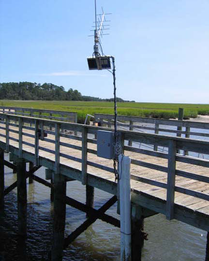
A Sutron Sat-Link2 transmitter was installed at the Lower Duplin station on March 18, 2007 and transmits data to the NOAA GOES satellite, NESDIS ID # 01 00 51 DE.
The transmissions are scheduled hourly and contain four (4) data sets reflecting fifteen minute data sampling intervals.
Upon receipt by the CDMO, the data undergoes the same automated primary QAQC process detailed in Section 2 above. The “real-time” telemetry data become part of the provisional dataset until undergoing secondary and tertiary QAQC and assimilation in the CDMO’s authoritative online database. Provisional and authoritative data are available at http://cdmo.baruch.sc.edu.
Before each YSI 6600 data logger is deployed, calibration and maintenance is performed following the manufacturer’s instructions. Calibration standards are only required for pH, conductivity, and turbidity, all other parameters are done as described in the manual. The conductivity, pH, and turbidity calibrations use a YSI produced traceable solution.
When deployed, the weather conditions and tidal stage are recorded in the field observation log. The datalogger is placed inside a length of PVC pipe attached to the dock. The data logger is attached to a non-floating dock by a monofilament cable and run down a PVC pipe to rest 0.5m above the surface bottom.
Because of the large tidal range, water is continually flushed through 2” holes in the PVC pipes at the sonde location, thus eliminating the problem of creating a stagnant column of water with in the pipe with data logger.
Every 15 minutes during the sampling period measurements are taken for
- temperature
- specific conductance
- salinity
- pH
- dissolved oxygen concentration
- percent saturation
- depth
- turbidity
At the end of the sample period the data logger is retrieved and immediately replaced by another calibrated data logger. The data logger is then taken to the lab and runs QA/QC standards for pH, and conductivity, and dissolved oxygen, the data are uploaded, and the sonde is cleaned. Data are removed if the post calibration standards fail or if technical problems are noted. All data removed is noted in the metadata.
Site Location and Character
The Lower Duplin (LD) monitoring site (31 deg 25′ 4″ N, 81 deg 17′ 46″ W) is located on the Marsh Landing Dock in the Duplin River on Sapelo Island and consists of a muddy bottom habitat.
Water passing the dock during flood tide originates from the Doboy Sound. The Doboy Sound receives input from the Atlantic Ocean, and the freshwater Altamaha River via the Intra-Coastal Waterway. The water is pushed up the river or up smaller tidal creeks and some is pushed onto the marsh surface by the flood tide and recedes into the main channel during ebb tide. Primary freshwater input consists of rainwater runoff.
The Marsh Landing dock is used as the main dock to the island where the ferry makes several daily runs, with several small boats that are docked there.
The surrounding area vegetation is dominated by salt marsh with Spartina being the predominate flora.
Normal tidal range for the site is 3meters and the salinity range is 5-35 ppt. The depth at this sampling station ranges from 2.5 meters to 6.0 meters depending on tide.
The Hunt Dock (HD) monitoring site (31 deg 28′ 43″, 81 deg 16′ 23″ W) is located on the Duplin River, off of Moses Hammock, which is separated from Sapelo Island by a small tidal channel.
The primary runoff at the site is from tidal creeks flowing through Spartina marsh and through the mud. Bottom habitat at this site includes soft mud and some oyster bed building along the shoreline with an average tidal range of 3meters and a salinity range of 5-35 ppt. Primary freshwater input consists of rainwater runoff.
There is little human traffic this far up the Duplin and it is north of the people living on Sapelo.
During the fall, the Hunt dock and Moses Hammock is the camping and docking site for deer hunters traveling to the island. These are controlled hunts and dates are available from the SAP NERR office if needed.
The maximum depth at the Hunt Dock site is 4.27 meters.
Dean Creek (DC), (N 31 23 22.5W 81 16 44.2) is located on a small wooden bridge spanning Dean Creek, in close proximity to the adjacent Nannygoat Beach causeway.
Dean Creek is a small tidal basin fed from the waters of Doboy Sound, which is located on Sapelo Island’s south end. The creeks’ salinity normally ranges between 5 and 30 ppt. Primary freshwater input consists of rainwater runoff.
The benthic community consists of a sandy-mud substrate with occasional, small, intertidal oyster reef community and mean tidal amplitude of approximately 3meters. The small creek feeds approximately 150 acres of Spartina alterniflora dominated salt marsh, which is interspersed with small 0.5-1 acre hammocks and saltpans. Fringe community components range from Loblolly pine forests with a sub-canopy of Yaupon holly to Wax myrtle and Sable Palm.
The Cabretta Creek (CA) site coordinates are N 31 26 37.3W 81 14 23.7. The station is located on a small (one-lane), wooden, roadway bridge spanning Cabretta creek located on the island’s extreme eastern side, bordering the Atlantic Ocean.
The creek is fed directly from waters of the Atlantic Ocean. Cabretta experiences an average tidal range of approximately 3 meters. Salinity ranges with exception to major, long-term precipitation events, varies from 15-36 ppt., seasonally. Primary freshwater input consists of rainwater runoff.
The benthos is composed primarily of sand substrate with small, intertidal oyster reef conglomerate communities. Adjacent to the site is extensive, intertidal, bank stabilization (armoring) in the form of woven rip-rap fencing and granite rocks. This manipulation is slowly becoming stabilized via oyster reef community colonization. The adjacent marshes are dominated by Spartina alterniflora with occasional Juncus romerianus in the nearby fringe community habitat.
The creek has very little adjacent uplands due to:
- The low elevational gradient.
- The areas geologically recent accretion genesis (Holocene) resulting in sandy soils; of which neither conditions allow for extensive floral colonization or stabilization.
There are no current studies on pollutants in this area. Sapelo Island is typically considered a pristine environment, with minimal pollutant input.